Portfolio - Rev 10 Ventures: v7
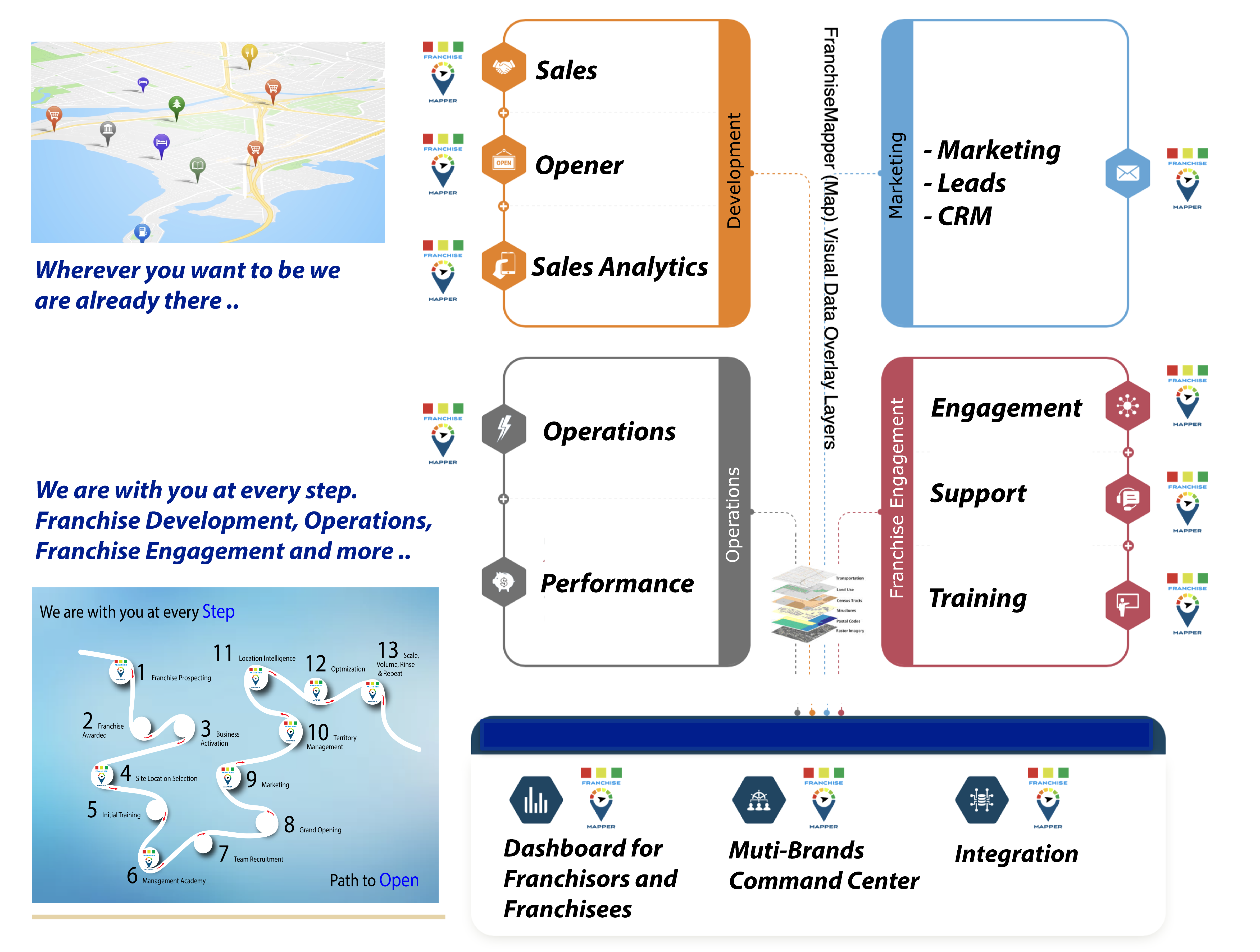
FranchiseMapper

Award-Winning Franchise Mapping ..
FranchiseMapper can Manage, Visualize and Scout your existing & new store locations on a map. See your locations, customers, partners, competitors or whatever you want to see on a map with real market demographic data points. Mapping Software Platform, Success, Easy 1-click solutions.
What would you like to know right now about every franchisee? FranchiseMapper can make that information available to you right at your fingertips, immediate, Accurate, and Actionable!
"Location intelligence is needed now more than ever"
Our technology grows your brand by providing territory mapping, demographic, marketing / lead generation, and infographic solutions for your company. We are experts in mapping, spatial analysis, maximizing franchise and non-franchise potential while assisting in growing your brand territories and marketing capabilities. Access over 15,000 demographic data points. We offer world-wide mapping and satellite image solutions for 130+ countries.
-
Franchisor / Franchisee Needs:
-
- Territory Mapping
-
- Dashboard
-
- Site Details Map Visualization
-
- Territory Market Analysis
-
- Territory Radius Analysis
-
- Satelite Imagery and Analysis
-
- Aerial Site Location
-
- Territory Heat Maps
-
- Executive Dash Board
Mapper Suite
Our "Mapper Suite" GIS product line provides XBRL Standard Government Reporting
Deploy new stores with just an internet connection: no installation, no specific hardware required. It works with any iPad, Tablet PC, laptop or industrial POS machine.

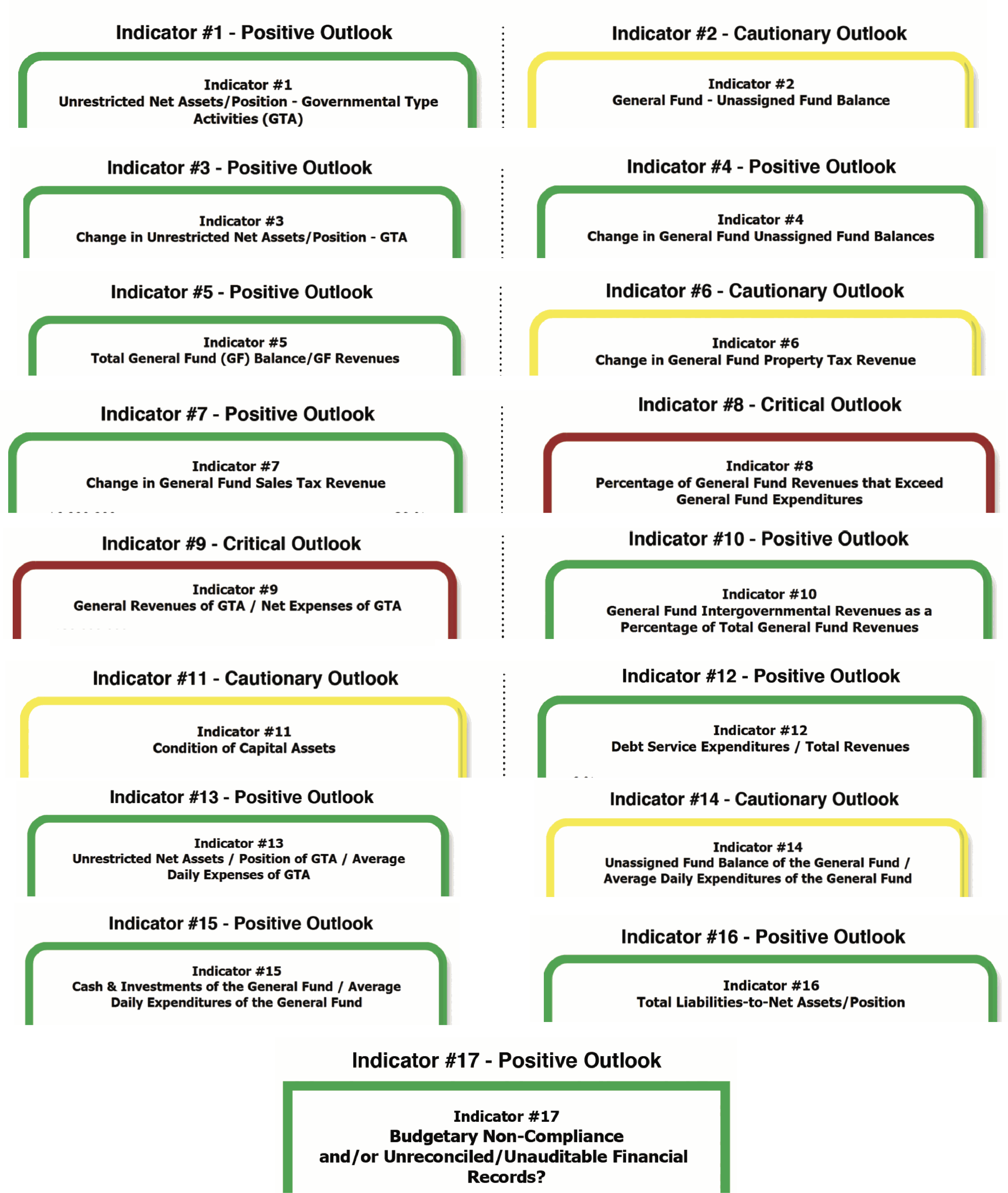
Our Rev10 Ventures - Mapper Suite product line provides XBRL taxonomies for state, county, municipal, and special district financial filings. Communicate with our Mapper Suite tools and XBR to help visualize your message spatially and providing data to make informed decisions. Need to visualize a GIS map of "Early Warning" Financial Indicators? The XBRL taxonomy to support this initiative is underway.
XBRL "Mapper Suite" - Services Provided:
-
1) Finance Mapper - Government Standards Financial Reporting
-
2) Audit Mapper - Government Standards for Audit Reporting
-
3) IFRS Mapper - (ISSB-International Sustainability Standards Board, CDSB-Climate
-
4) SEC Mapper - Securities Financial Reporting
-
5) CDO Mapper - Chief Data Officers Council
-
6) SASB Mapper - Consumer Goods, Extractives & Minerals Processing, Financials, Food & Beverage, Health Care, Infrastructure, Renewables Resources & Alternative Energy, Resource Transformation, Services, Technology & Communications, Transportation.
-
7) PDF Writer/Reader - This is no ordinary static PDF. Do you want to make your PDF's come-alive. Do you want to make your PDF's interactive. Click on the layers feature and watch your PDF information display layers-of-data information.
-
-
-
Wow, you need this, this is amazing ...
- Request a demo of our "Early Warning" System Financial Health Indicators. Our GIS "Mapper Suite" XBRL Visualization Tools is a 'game-changer'. We would like to partner with you and tailor a solution for you!
Government Needs:
-
- Asset Tracking and Analysis
-
- Civic Inclusion
-
- Crisis Response
-
- Economic Development
-
- Operational Efficiency
-
- Planning for Sustainability
-
- Safety and Security
-
- Situational Awareness
-

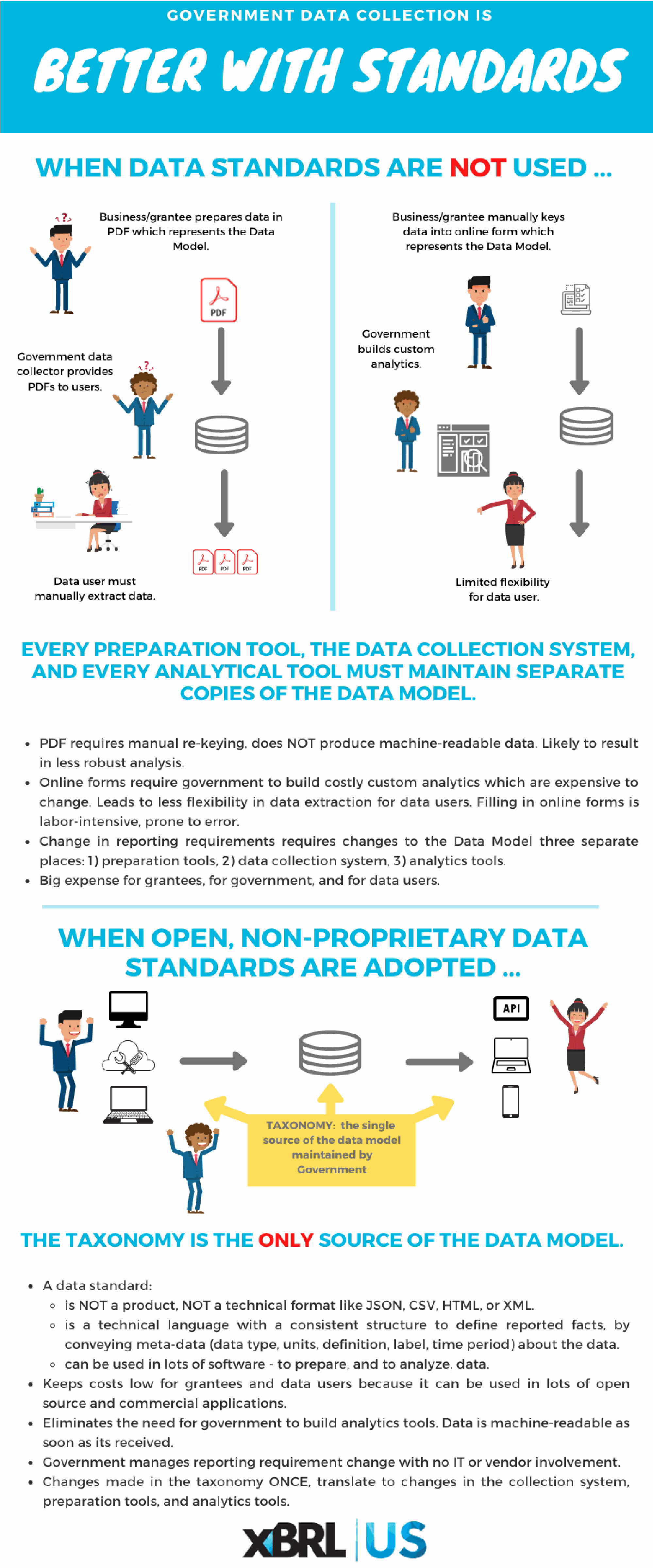
The Securities and Exchange Commission (SEC) adopted the XBRL technical specification that combines an HTML and an XBRL document, for reporting by operating companies and mutual funds. XBRL is an ideal tool for CAFR reporting, as it can transform a state’s CAFR into a single document which is both computer-readable and human-readable.
The Grants Reporting Efficiency and Transparency (GREAT) Act
Was signed into law December 30, 2019, mandates data standards for federal awards by 2022; and for Single Audit data by 2023. The Act states that data standards shall: “…render information reported by recipients of Federal awards fully searchable and machine-readable; be nonproprietary; incorporate standards developed and maintained by voluntary consensus standards bodies; be consistent with and implement applicable accounting and reporting principles; and incorporate the data standards established under the Federal Funding Accountability and Transparency Act of 2006 (31 U.S.C. 6101 note). “
Single Audit Taxonomy which is included as an entry point in the CAFR (Comprehensive Annual Financial Report) demonstration taxonomy. The Single Audit Taxonomy includes the Schedule of Expenditures of Federal Awards, and the Schedule of Findings and Questioned Costs.
DATA Act
The Digital Accountability and Transparency (DATA) Act , signed into law on May 9, 2014, mandates structured data standards for government with objectives to 1) establish government-wide financial data standards and increase the availability, accuracy, and usefulness of Federal spending information, 2) amend the Federal Funding Accountability and Transparency Act (FFATA), and 3) develop Government-wide data standards to simplify financial reporting, and improve the quality of spending data. Get details on the DATA Act Information Management Standard v1.0. Learn more about the final data standards.
Heartland GIS

Award-Winning Mapping ..
Heartland GIS has designed award winning and nationally recognized GIS systems. Our maps have won many peer-reviewed awards for communicative mapping. Our focus is about helping you visualize your message spatially and providing data to make informed decisions. Specializing in providing GIS solutions to Federal, State, and Local governments.
Sample Clients Real World Problem Solving:
Heartland GIS provides a wide-spectrum of GIS services. We recognize that every GIS situation is different and provides solutions to solving your geospatial needs. Our services are designed to provide you exactly what you need and not pay or spend time and resources for services that are not needed.
For over 25-years Heartland GIS specializes in providing GIS services to organizations that need GIS technologies but may not be able to fund a position or the necessary hardware/software infrastructure. Heartland GIS can provide ad hoc services such as data management or map production or be on retainer to serve as many GIS needs are necessary for the life of a single project or over many years. We can work with you to provide a GIS solution that best meets your needs.
Overview: Heartland GIS provides a wide-spectrum of GIS services. Heartland GIS recognizes that every GIS situation is different and does not provide a cookie-cutter approach to solving your geospatial needs. We have worked on projects involving millions of data records to small membership lists. Our services are designed to provide you exactly what you need and not pay or spend time and resources for services that are not needed.
Heartland GIS can help identify what the exact problems are and develop solutions for the short, mid-term and long range needs of your organization.Heartland GIS also specializes in GIS Consulting, Online Portal Development, Agriculture, Agribusiness, Communicative Mapping, Archaeological/Historical/Cultural Resource Data management GIS services.
Services Provided: Application Development, Business Case Development, Data Conversion/Migration, Data Model & Database Design, GIS Strategy and Planning, Hosting Services, Implementation, Needs and Requirements, System Architecture and Design, System Integration
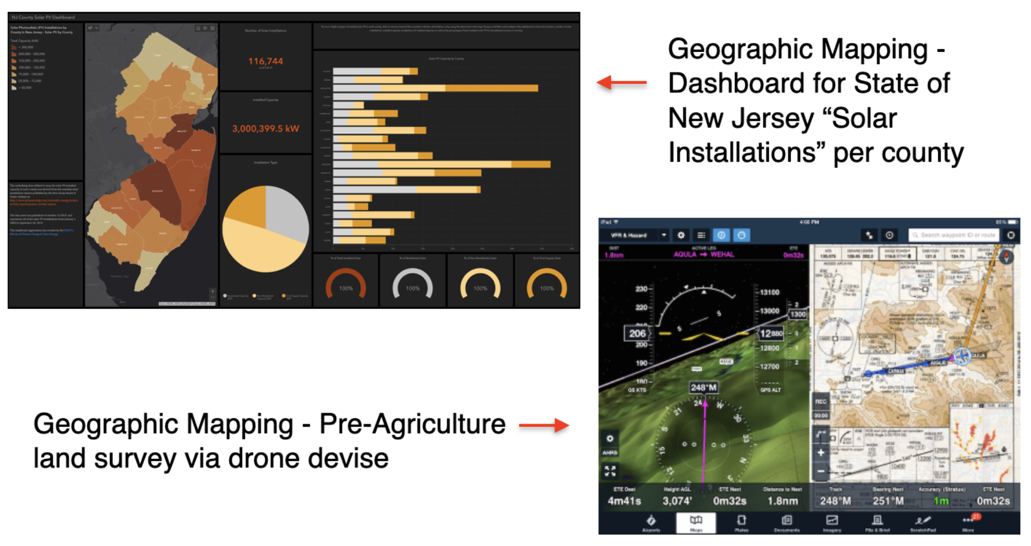
Sample: New Jersey:
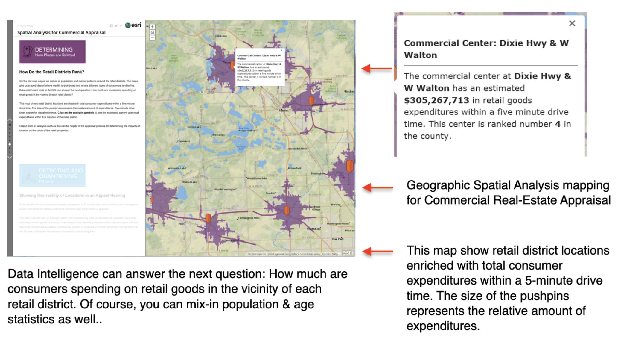
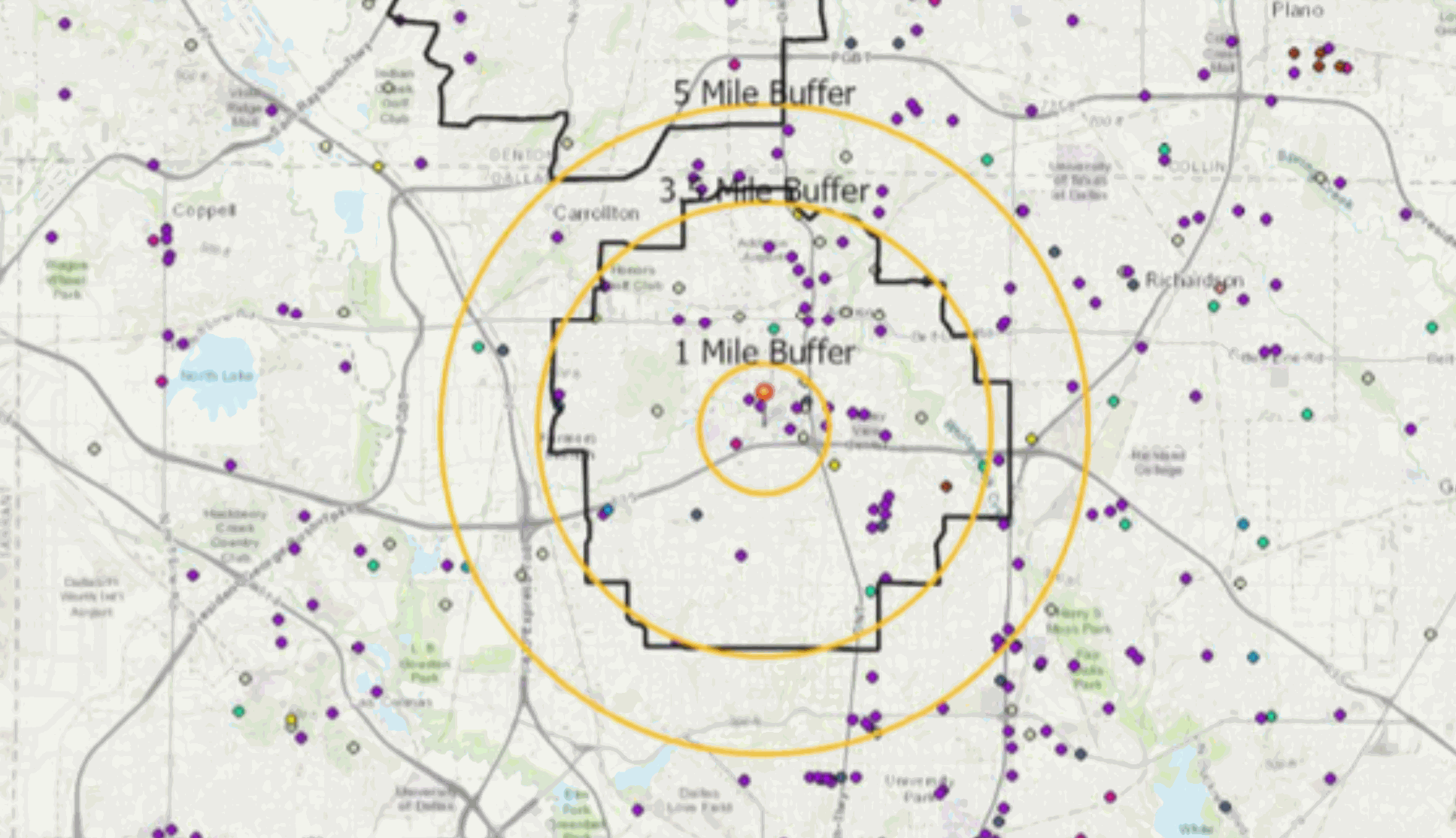
Sample: Retail - Real Estate: